


Roman Settlements, Towns and Cities
Ascertaining the status of a town
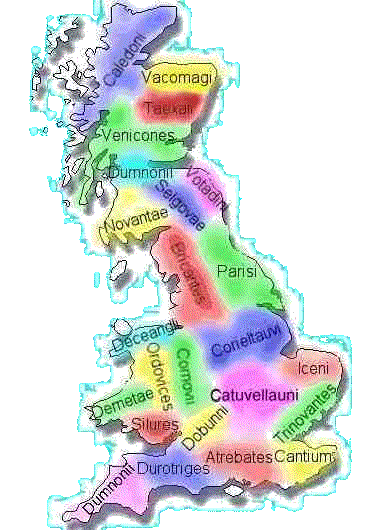 As an be seen from the map of the tribe distribution in Britain, the country was divided into sections,each occupied by a group of natives. There were not towns as we know them today, just settlements and villages, along with farms and fortress type houses for the rulers of each tribe. To them, many of their larger villages were looked upon as towns.
In terms of population, the country was not as we know it today. Each tribal area had set boundaries which were only crossed by travelers or traders. Certainly no warriors would stray into another tribes territory as this could be taken as a sign of potential invasion. The reaction of the offended tribe would have been swift and fierce.
When the Romans arrived, they changed the landscape by creating centres scattered around the country. The larger of these, Londinium, Colchester and Verulamium were designated the three largest towns in Britain. But what designated a town from a village?
To the Romans physical size and population were not the overriding factors. It was how important the town was that decided it's standing, when matched with other towns. Consideration was given to such aspects as :
- How much national administration was centred there?
- Did it have a high ranking figure living there?
- Was it at a major junction in the road or river network?
|
|
These were just a few factors taken into account when deciding the status of a town. Today we have such designations as city, town, village, borough, hamlet, in fact a whole host of terms to describe a landscape. The Roman equivalents were municipium, vicus, oppidum, urbs, civitas. Even the Greek word polis was used.
It has been argued over many years what constitutes a town and what is a city. By and large, the opinions sway towards coloniae and municipia being cities since they had received a charter of independence.
The Structure of the Towns
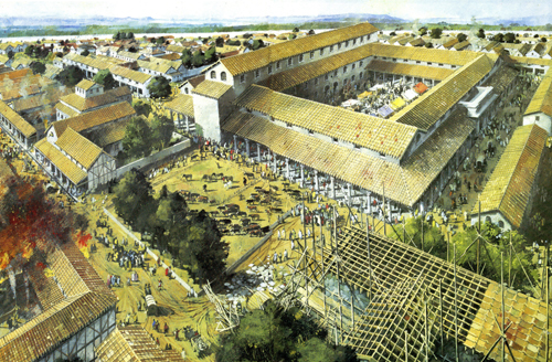
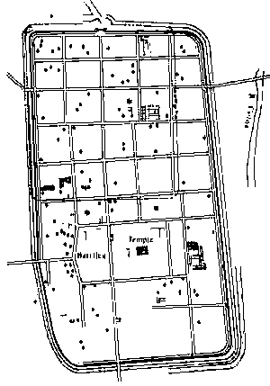 2000 years ago the Romans built their towns in the fashion of 'blocks' (insulae). Rectangular and square plots surrounded by streets. Take a look at the layout of any Roman town and a clear pattern of square and rectangular areas is evident. The picture left shows Colchester, one of the largest towns in Britain, and clearly shows the square layout of the areas between the streets.
The centre of the town would have held the Roman governor of the area along with his administration staff. The tribal leader would have had a town house to enable attendance at council meetings. Even so, the king of each tribe retained his stately house within the boundaries of his predefined area and resided there to attend to day to day matters in administering his people.
Within the towns, which were walled later in British Roman history lived the traders, inhabitants and the military that defended the area occupied by the town and the land outside the perimeter.
Apart from agriculture and food, the towns were largely self sufficient, holding all the people and skills needed to see to the daily needs and to expand the scope of the facilities within.
Within each area would be the main town (civitas capital) where the Romans would have an internal governor. This would be someone high in Roman office who reported to the provincial governor of Britain, who, in turn, reported directly to Rome.
Although it is not apparent in the map above, Roman towns were generally laid out in a similar fashion with two main streets meeting in a crossroads at the centre. These streets were called the cardo maximus and the decumanus maximus. Here was the main centre of the town and was also the place where important buildings such as the forum and basilica and the main public buildings would reside.
The Towns Themselves
 The Romans have very strict rules when planning towns and the streets and buildings within them. As mentioned above, the towns where built around a square format with all the streets either being parallel or at right angles to each other. It was an offence to construct any building so that it interfered with the public right of way.
The streets themselves were laid using local materials, with gravel and limestone being most commonly used as they will compact and become more solid due to the actions of wear and the weather. The streets were cambered so that the middle was slightly higher than the sides, thereby allowing rain water to flow into the side drains on each side of the street. In time the surface would wear and so any potholes were filled with the standard materials used. over a period of time, the surface level of the street would rise due to the accumulation of dust and mud. Along with the resurfacing work, this would cause annoyance to those that lived and worked alongside, as the height of the road would gradually increase. This had the resultant effect of making their properties appear lower than when they had originally been built. It also meant that when their house or shop had been built it was level with the road, and many years later they had to come out into the street and take a step up. This meant the house would often have to be raised, or in extreme case, demolished and rebuilt. Archaeologists have uncovered remains where the road has been raised by nearly 10 ft. (3 metres) over a 300 year period. This meant a rise of about 0.4in (1 cm) per year.
In the chartered towns, the administration would be performed by two magistrates, who presided over a council of up to 100 members.
The Buildings within the Towns
The forum was usually a large open space surrounded on three sides by porticoes, with shops and offices fronting it. The basilica would occupy the fourth side and the complex would have an elaborate entrance in the middle facing the basilica.
The basilica was a long aisled hall and at each end were raised platforms, used by the magistrates for official business. On the side away from the forum were a series of rooms which were used by council officers and for meetings. One room placed in the centre was reserved for statues of the emperors or local protective deities.
The forum was used for political gatherings and also for a wide range of activities such as markets with the customary traders plying their wares. Therefore of a settlement had a basilica and a forum, it could safely be referred to as a town. Considering that most of these have a military appearance to them leads us to believe that the architects used had their origins in designing forts and army buildings.
The Amenities that Served the Towns
There is another aspect that gives us a clue as to whether we are dealing with a town or a settlement, and that is in the provision of amenities. By this we mean having streets constructed to a high standard, a supply of running water from an aqueduct, and adequate water disposal booth in the streets and the sewers. A reasonable standard of dwellings, with domestic facilities and a well founded life of leisure and entertainment and education.
 The aqueduct channels that brought water to the town were of fairly basic construction. Britain was fairly flat in terms of the differences in height of the landscape over a given area, and so made the transporting of water a less complicated affair than on the continent where the hills and valleys were more pronounced. Wherever the nearest highest source of water was found, here was the source for the town. Either a damn was built, or a spring diverted so the water ran along contoured channels dug in the ground in a manner and route that would take the most advantage of gravity.
However, where the landscape called for more elaborate means, the Roman engineers really showed their mettle. Lincoln (Lindum) had a more complex arrangement as the water had longer to flow and also had to negotiate rougher terrain that most other towns. In places the water was carried along ceramic pipes, encased in concrete so the pipes would withstand the force of water traveling through them. A system like this could easily transport hundereds of thousands of gallons of water a day.
There was one major problem with n aqueduct. It could not have it's flow restricted in the manner we take for granted today. When heavy rains came, the risk of flooding was severe, and so the only effective way to prevent this was to had a very effective method of removing the water from the town. via the sewerage system.
The Restructuring of Britain
When the Romans conquered a country, or a large area of a country, they immediately set about restructuring the land into manageable divisions. In such places as Britain, this was made easier by the way in which the current natives had divided the country into regions based on the land occupied by individual tribes. The Romans gave these areas the name of civitas with a constitution and carefully laid out duties and rights. The main town within this area was designated the civitas capital. In Britain, the Romans saw no evidence of a large town anywhere after the invasion. In 49 AD. they began to teach the Roman way of living to the British by founding Colchester on the sight of an abandoned fortress. In doing so they were making use of land that the Romans had ownership over.
Colchester (Camulodunum) was inhabited by retired legionaries, most probably from Legion XX. Each inhabitant of the town was given a plot of land, on which was his house, and a larger plot outside the town. This land (territorium) was deemed to be part of the town. This was a large area, probably as much as 640 sq. miles (400 sq. km). Imagine an area more than 25 miles by 25 miles square (20 km x 20 km) and you get some idea of the amount of land the Romans took from the Triovantes tribe that already lived there. This formation of such a large area that was under Roman ownership may well have contributed to the Boudiccan rebellion of 60/61 AD. It certainly did not do much to appease the Triovantes.
Later towards the end of the first century, two more chartered coloniae were founded at Lincoln and Gloucester. Both were based at the sites of abandoned fortresses of Legion IX and Legion II Augusta. In both cases the Romans needed extra land. This was done by buying plots from the Corieltauvi and Dobunni tribes. It is interesting to note that the Romans bought this land, rather than just acquired it. Since the Boudiccan rebellion, Britain had gone through a period of change and recovery , with the Romans learning that it was better to persuade the natives, rather than starting a confrontation and forcing them to accept Roman ways.
In later times, the Romans had adapted and were using the method of promoting existing towns to a higher status, and so a fourth colonia was established at York, which later became the capital of Britannia Inferior. This caused a conflict of interests, as the promotion of towns was done on a gradual process. The first step was to make the town a municipium . In Britain there were two types of law that applied to these new towns
- Latin Law where some of the established native laws still applied.
- Full Roman Law, where the native laws did not apply and were replaced by the Roman constitution.
Understandably, the natives preferred Latin Law, as they did at least, retain some power.
The next was Verulamium and probably even later, Canterbury, Dorchester and Leicester were given this status.
In all this, the question remains of London (Londinium). Where did the capital of Britain fit into all this? London became a municipium towards the end of the first century, but was never part of the local government network. It was the capital of Britannia and probably promoted to colonia in the fourth century and given the honourary title of Augusta.
Either way, the towns were self governing communities that took directions from the provincial governor. He would be in contact with Rome, where most final decisions started life.
Read More
- Roman Towns, a page on the Time Trips website. Great info and art. Give it a look.
- Canterbury Archaeological Trust website: An invaluable look at the history of this town thorugh their architecture. Good Roman info.